Salt Domes And Salt Glaciers of Zagros Mountains
Salt domes and salt glaciers are unique geological formations found in the Zagros Mountains of Iran. Salt domes are formed when salt deposits are pushed up through the Earth's crust, creating a dome-shaped structure. Salt glaciers are formed when salt flows down a slope, like a glacier.
Salt Dome
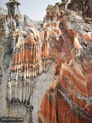
Salt mountains, also known as salt domes. These natural wonders are formed over millions of years as salt deposits push their way up through the Earth's crust, creating dramatic and colorful landscapes.
Salt dome is a mushroom-shaped geological structure formed when a thick layer of salt is buried under layers of other rocks. The salt is less dense than the surrounding rocks, so it pushes its way upwards to form a dome.
In the southern part of the Zagros Mountains alone, there are more than 130 salt domes which affected the structure of Zagros Mountains as one of the most significant simple folded systems in the world.
Aside from salt domes, there are salt caves including the longest salt cave in the world at over 6.4 km in the Namakdan Mountain, salt glaciers, salt valleys, karst sinkholes, and salt springs.
.jpg) |
| Salt Domes And Salt Glaciers of Zagros Mountains |
Salt Glacier
A salt glacier (or namakier) is a rare flow of salt that is created when a rising diapir in a salt dome breaches the surface of the Earth. The name ‘salt glacier’ was given to this phenomenon due to the similarity of movement when compared with ice glaciers. The causes of these formations is primarily due to salt's unique properties and its surrounding geologic environment. A rising body of salt is referred to as a diapir; which rises to the surface and feeds the salt glacier. Salt structures are usually composed of halite, anhydrite, gypsum and clay minerals.
Salt glaciers form because salt is a relatively ductile material. This means that it can deform and flow under pressure. The weight of the overlying rock layers and the pressure of the salt itself cause the salt dome to rise. When the salt dome reaches the surface, it can breach and form a salt glacier.
 |
| Photo: Philippe Crochet |
Zagros Mountains
The Zagros Mountains are a mountain range that stretches from eastern Turkey to southeastern Iran.
The salt domes are one of the main units of structural geomorphology of Iran. Those with highest density are formed in Zagros Folded zones, Persian Gulf region, and rarely in central Iran and Azerbaijan. The main area the domes are originating is Hormoz Formation related to Infra-Cambrian.
The sources of salt glaciers are salt deposits. Over time sediments, rock and debris cover the deposit causing layers to build up over the salt. Due to its crystalline structure, salt remains at the same density while the sediment above begins to compress and become denser. The density contrast is the mechanism in which salt begins to rise. Diapirs rise and pierce the surface allowing the salt to flow because of gravity. Piercing the overburden is crucial for salt glaciers to form, and can occur in three ways.
 |
| Photo: saltytour.com |
Active diapirism develops as the rising salt itself pushes and forces the overburden upward and sideways. Passive diapirism occurs when the salt always remains near the surface and the sediment builds up around it rather than over it. Reactive diapirism is the result of regional extension caused by rifting.The overburden becomes weak and thin which allows the salt body to travel upwards.
Salt glaciers are a frequent topic in salt tectonics, which is the study of salt causing deformation and its leading cause is differential loading (an unevenly distributed load). Differential loading can be caused by displacement, gravitational and thermal gradients. Other tectonics may cause salt deposit uplift. The strength of the overburden and drag of the salt deposit boundary are the two factors that will slow and prevent salt flow and it will only move if the salt forces exceed the resistant forces.
Associated Geological Processes
Tectonic Activity: The Zagros Mountains are situated in a tectonically active region where the Arabian Plate is colliding with the Eurasian Plate. This tectonic activity has played a crucial role in the deformation and movement of salt layers within the Earth's crust.
Hydrocarbon Traps: Salt domes are significant geological features as they can create traps for hydrocarbons. Overlying sedimentary layers can deform around the salt structures, forming reservoirs for oil and gas.
Photos of Salt domes and salt Glaciers
 |
| Photo: saltytour.com |
 |
| Salt domes and salt Glaciers. Photo: Mas Mozaffary |
.jpeg) |
| Salt domes and salt Glaciers, Zagros, Iran |

Salt domes, Iran
Photo: Mohammad.Alinia.53

Salt domes, Iran
Photo: Mohammad.Alinia.53
 |
| Salt mountains, Iran Photo: Mohammad.Alinia.53 |
 |
| Salt mountains, also known as salt domes, Iran Photo: Mohammad.Alinia.53 |
The Zagros Mountains provide a fascinating geological setting for the study of salt tectonics, and the presence of salt domes and salt glaciers underscores the complex interplay of tectonic forces and the movement of subsurface materials in this region. These geological features have practical implications for various industries, including oil and gas exploration.
See also:
Richat Structure: Geological Wonder in the Sahara Desert
China’s Mysterious Egg-Laying Mountain That Spews Out Stone Eggs


