Sequence Stratigraphy
Sequence stratigraphy is a branch of geology, particularly sedimentary stratigraphy, that focuses on understanding the organization of sedimentary rocks through time. It analyzes these rocks by dividing them into sequences based on changes in sea level, sediment supply, and accommodation space.
The key concepts:
Sequences: These are layers of sedimentary rock that represent a complete cycle of sea-level rise and fall. A sequence typically includes deposits from lowstand (when sea level falls), transgressive (when sea level rises and floods the land), and highstand (when sea level is relatively stable) conditions.
Sea-level change: The primary driver behind sequence formation. Sea-level fluctuations control the location of deposition (closer to shore during lowstands, further offshore during highstands) and the amount of space available for sediments (accommodation space).
Sediment supply: The amount of sediment delivered to a basin also influences sequence formation. High sediment supply can fill accommodation space more quickly, while low supply can result in gaps in the sedimentary record.
Accommodation space: This refers to the available space for sediment deposition. Rising sea level creates more space, while falling sea level reduces it.
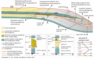
An increasingly popular way of dividing up the stratigraphic record is on the basis of unconformities into sequences. See Figs 1 and 2 for the basic models. A sequence is defined as a succession of relatively conformable, genetically related strata bounded by an unconformity or its correlative conformity. An unconformity (the sequence boundary) is a surface separating younger from older strata along which there is evidence of subaerial exposure with a significant hiatus (type A) or of drowning (type B). It will pass laterally (basinwards) into a conformity.
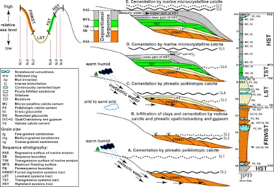
A sequence can usually be divided into systems tracts (defined as a linkage of contemporaneous depositional systems, i.e. related facies, or facies association) deposited during a specific part of a cycle of relative sea-level (RSL) change, i.e., falling stage systems tract (FSST), also called forced regressive (FRST), when RSL is falling; lowstand systems tract (LST; RSL is low); transgressive systems tract (TST; RSL is rising), and highstand systems tract (HST; RSL is high) (see Figs 1 and 2).
Apart from the sequence boundary (sb), other key surfaces are the transgressive surface (ts), which may be coincident with the sequence boundary in more proximal (landward) parts of a basin, at the base of the TST, and the maximum flooding surface (mfs) that separates the TST from the HST (see Figs 1 and 2).
In more distal parts of the basin, there is commonly a condensed section (cs) equivalent to the upper part of the TST, the mfs and the lower part of the HST. The sequence stratigraphic terms are defined in the Table. There are some significant differences in the sequence stratigraphic models for clastics and carbonates (see Figs 1 and 2) in view of the different controls on sedimentation, notably the mostly in situ generation of carbonate sediments and the imported nature of clastic sediments.
Some sequences, especially in platform carbonates, are composed of several or many metre-scale cycles termed parasequences (defined by flooding surfaces at their bases), and then the systems tracts are defined by the stacking patterns of the parasequences (e.g., whether they thin/thicken-up or fine/coarsen-up). See Section 8.4 for further information on how to recognize the key surfaces and systems tracts in the field, and what features to look for in successions of parasequences.
Sequences within an area are generally named by letters or numbers, or a combination of both, working from the base upwards.
Systems Tracts
The concept of systems tract evolved to link the contemporaneous depositional systems. Systems tract forms subdivision in a sequence. Different kind of systems tracts are assigned on the basis of stratal stacking pattern, position in a sequence and in the sea level curve and types of bounding surfaces.
Lowstand Systems Tract (LST): Deposited during falling sea level, often consisting of coarse-grained sediments. Low stand forms when the rate of sedimentation outpaces the rate of sea level curve during the early stage of sea level rise. It is bounded by subaerial unconformity or its correlative conformity at the base and maximum regressive surface at the top.
Transgressive Systems Tract (TST): Deposited during rising sea level, often consisting of fine-grained sediments. Transgressive systems tract is bounded by maximum regressive surface at the base and maximum flooding surface at the top. This systems tracts forms when the rate of sedimentation is outpaced by the rate of sea level rise in the sea level curve.
Highstand Systems Tract (HST): Deposited during high sea level, often consisting of thick prograding wedges of sediment. Highstand occurs during the late stage of base level rise the rate of sea level rise drops below the sedimentation rate. In this period of sea level highstand is formed. It is bounded by maximum flooding surface at the base and composite surface at the top.
Regressive systems tract (RST): Regressive systems tract forms in the marine part of the basin during the base level fall. Subaerial unconformities form in the landward side of the basin at the same time.
Parasequences and stacking patterns
A parasequence is a relatively conformable, genetically related succession of beds and bedsets bounded by marine flooding surfaces and their correlative surfaces. The flooding surfaces bounding parasequences are not of the same scale as the regional transgressive surface that is associated with a sequence boundary.
The parasequences are the separated into stacking patterns:
- Aggradational
- Progradational
- Retrogradational
Each stacking pattern will give different information on the behaviour of accommodation space, a major control of which is relative level. So a rapidly progradational pattern will be indicative of falling sea level, rapidly retrogradational is evidence for rapidly transgressing sea level and aggradational will be indicative of gently rising sea level.
Benefits of Sequence Stratigraphy
Correlation: Allows geologists to correlate sedimentary rocks across vast distances by recognizing similar sequences and depositional patterns.
Reservoir Prediction: Helps identify potential locations for hydrocarbon reservoirs by understanding how sea-level changes influenced sediment distribution.
Basin Analysis: Provides a framework for understanding the long-term evolution of sedimentary basins.


